A Civil War heritage trail in Spain
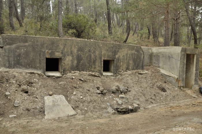
A Spanish Civil War bunker near Loma Quemada. Photo Sextante, es.wikiloc.com.
Alasdair Fotheringham, writing for The Independent, explores a curiously uninformative official heritage trail–the first of its kind established by a governmental entity–commemorating a Spanish Civil War battlefield outside of Madrid:
Perhaps it is appropriate that there are no explanatory signboards (although, apparently, these will be installed soon) to indicate where this trail starts, let alone a visitors’ centre or car park. Instead, there is just a half-metre-high metal post with three words on it: Ruta Guerra Civil (Civil War Trail). …
The first signpost, on the right, is up to the Loma Quemada (Burnt Slope) defence system, a large series of sharply undulating Republican trench networks. Now smothered in a dense orange bed of pine needles, in the eerie silence it is hard to imagine their importance. Until, that is, you walk a little further and the trenches’ commanding position over a heart-stopping descent into a valley below suddenly explains things.
Read the whole article here:
Frontline drama in Spain
Alasdair Fotheringham follows the first heritage trail to focus on the Spanish Civil War
Should we really be surprised that Spain’s first heritage trail on its Civil War – in the woodland sierras north of Madrid – is far from being a swanky, state-of-the-art affair?
Quite apart from the austerity measures wreaking havoc in the country’s public funds, the 1936-39 conflict remains a delicate subject for Spain’s older generations. It pitted the fragile elected government on the Republican side against the Nationalist rebels led by General Franco – who subsequently became Spain’s fascist dictator for 36 years. It is believed that 140,000 Republicans killed by Nationalist death squads remain unidentified in mass graves on the country’s quieter roadsides and mountain ravines
So perhaps it is appropriate that there are no explanatory signboards (although, apparently, these will be installed soon) to indicate where this trail starts, let alone a visitors’ centre or car park. Instead, there is just a half-metre-high metal post with three words on it: Ruta Guerra Civil (Civil War Trail).
The trail was created by the Madrid regional government’s cultural heritage department. Feeling distinctly un-bombarded by information, you follow the sign up a rutted moorland track to the edge of a wood.
Shimmering in the distance behind you is all the explanation you really need for why this segment of frontline between the Nationalist and Republican sides in the Civil War was so important. It was known as the Frente del Agua (The Water Frontline). Eighty years ago the reservoir of Puentes Viejas was Madrid’s only water supply. Had the Republicans lost the reservoir, the odds are they would quickly have lost the Spanish capital and the Civil War.
Instead, after a ferocious battle which ended in stalemate, the Republicans held their position, the reservoir and Madrid. They maintained control right until the end of the conflict, on 1 April 1939, when the capital fell without a shot being fired. And as one of the most solid frontlines of the war, its comparative isolation has allowed the Frente del Agua to become one of Spain’s best preserved battlegrounds.
Once inside the sizeable wood of tall firs and holm oaks, a rough forest track winds its way upwards to the main frontline that was once “home” to around 4,000 troops. From time to time, small wooden posts for the Guerra Civil trail indicate a dozen different locations of machine-gun posts, sniper positions, and what investigating archeologists say are “hundreds of kilometres of trenches”, even a command post. This was, in the words of Republican general Vicente Rojo, central Spain’s “most important series of fortifications.”
The first signpost, on the right, is up to the Loma Quemada (Burnt Slope) defence system, a large series of sharply undulating Republican trench networks. Now smothered in a dense orange bed of pine needles, in the eerie silence it is hard to imagine their importance. Until, that is, you walk a little further and the trenches’ commanding position over a heart-stopping descent into a valley below suddenly explains things.
A few hundred metres on, another tiny metal sign points towards one of three machine-gun posts. This one, a Republican strongpoint of reinforced concrete and brick 10m high, is sunk deep into the hillside. When you clamber down a narrow earth stairway, there is barely room to stand and just two giant but painfully narrow slits for visibility and ventilation. For a clammy, claustrophobic atmosphere, it seems difficult to match – until I cross the former frontline (indicated by two tiny posts on each side of the forest track) and find two more, even better preserved Nationalist mini-fortresses.
Like the first strongpoint, the Nationalist lines have withstood the test of time almost perfectly. Narrow slits point ominously at the frontline. The final construction, reached after about 3km of steady woodland walking, looks even more unchanged. It is a Nationalist command centre with two large rooms inside, plus a well-preserved fireplace. The date engraved on the doorway plinth, May 1938, tells you when it was built. The huge Fascist arrows-and-yoke symbol carved on the wall outside tells you which side it was built for. Look for Arriba España – the Nationalist salute, meaning “Onwards Spain” – engraved on the doorposts.
The delay in creating the first Civil War heritage trail is only partly explained by Spain’s chronic inability to find closure for some of the conflict’s legacies. As Inmaculada Rus, an archeologist with the cultural heritage department, explains, Spanish legislation for the establishment of historical sites that are less than 100 years old came into force only this year. But she says interest in such places is growing fast: “This one in particular remains in very good shape, because there has been very little urban development. The only real change since the war is that the trees have grown a lot higher.”
As an archeologist, she believes “it’s our obligation to bring this heritage out to the light. Then what you think of it is up to you. This is a way of normalising things.” A heritage trail, then, that leads to more places than one.
Getting there
The easiest way is by car. Drive north on the A-1 from Madrid towards Burgos for around 60km and then take the exit at km67 towards M-135/Mangiron. After 10km, take the left-hand road towards Montejo de las Sierra and cross the head of the Puentes Viejas reservoir. After 200m, on the left, is a small sign marking the start of the trail. The trail takes roughtly three hours. Bring walking shoes and be prepared for a scramble.


This is very interesting! Thanks for sharing! However, the author’s first sentence (in the complete article) is not exactly correct. This is not “the first” interpretive route in Spain devoted to the Spanish Civil War. Rather, Aragon has developed a variety of historical sites in Los Monegros: http://www.redaragon.com/turismo/orwell/ While the sites are largely focused George Orwell’s experience, they do all discuss the general experience at the front in Los Monegros.
Could you put the full text of this interesting article on the ALBA website? The Independent requires payment for access after a certain number of articles, a number I have exceeded.
Thanks.
Done!
sf